
Karnataka Survey Documents (Tippan, Akarband, FMB): The Record Your RTC Actually Comes From
Here’s something most guides skip. Your Bhoomi RTC Online record doesn’t create itself. It’s built on top of an older record called the Akarband — the original village survey register. If a survey document and your RTC disagree on boundaries, the survey document usually wins. It’s treated as the source of truth.
This guide covers every type of Karnataka survey document. That includes the Survey Sketch, Tippan, Akarband, Podi, and FMB. You’ll learn what each one proves, how to get them, and where the online process quietly stops.
What Are Survey Documents, Exactly?
“Survey documents” isn’t one document. It’s a family of related records. Each one was created during the government’s original land survey. Together, they define a parcel’s boundaries, measurements, and classification. They don’t tell you who owns the land — that’s the RTC’s job.
| Document | What It Actually Is |
|---|---|
| Akarband | The village survey register. It’s the master ledger listing every survey number with its original area, classification, and assessment. The RTC, maps, and mutations are all built from it. |
| Tippan / FMB (Field Measurement Book) | The original field record from the settlement survey. It shows precise measurements and bearings for a parcel’s boundary. This is the go-to reference when a boundary dispute needs resolving. |
| 11E Sketch | A survey drawing required before you can register the sale of part of a survey number. Without it, the Sub-Registrar can’t register the transfer. |
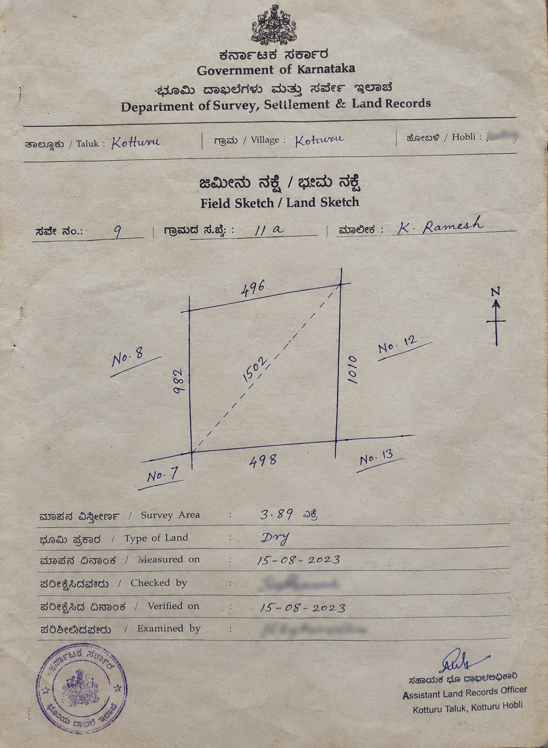
| Survey Sketch | A drawn diagram of a parcel’s shape and boundaries. It’s more visual and less technical than a raw Tippan. |
| Podi | Records created when a survey number is officially sub-divided. They track how one parcel split into separate hissas over time. |
| Village Map / Atlas | A map showing every surveyed parcel in a village. Useful for seeing a plot next to its neighbors. |
Karnataka identifies land using three linked numbers. These are the Main Survey Number, the Surnoc (a further division), and the Hissa (the smallest sub-division). A typical reference looks like 45/2A. Here, 45 is the main number and 2A is the Hissa. All three should match exactly across your RTC, Sale Deed, and survey documents.
Why the Akarband Matters More Than People Realize
The Akarband isn’t just background paperwork. It’s the record that first assigned a survey number its area, classification, and tax assessment. Every RTC entry, every mutation, and every later map trace back to it.
IN PRACTICE
If a dispute comes down to “what was this land originally classified as,” the Akarband settles it — not the current RTC.
Tippan / FMB — The Document That Resolves Boundary Disputes
Say two neighbors disagree about exactly where their boundary sits. Or a buyer suspects a plot’s shape doesn’t match its paperwork. The RTC won’t help here — it has no boundary data at all.
The Tippan (also called the Field Measurement Book, or FMB) is different. It’s the original field-surveyed record, with real bearings and measurements. It’s the closest thing to ground truth that exists on paper.
WHY IT HOLDS UP
Courts and licensed surveyors rely on this document for a reason. When a partition or boundary dispute needs the original settlement data, a redrawn copy won’t do. They need the Tippan itself.
How to Get Survey Documents — Where Online Stops and In-Person Starts
Most guides gloss over this part. Here’s the truth: not every survey document works the same way online. And one portal name gets misused constantly — people often say “check Mojini” when they actually mean two different things.
Bhoomi vs Bhoomojini (Mojini v3) — Two Different Portals, Two Different Jobs
People often say “check Mojini” when they actually mean two different things.
Bhoomi — Revenue Maps / SSLR
landrecords.karnataka.gov.in
This is where existing records — the Akarband, village Atlas, old plane-table sheets — are viewed. Search the same way you would for an RTC: District → Taluk → Hobli → Village → Survey Number.
Bhoomojini (Mojini v3)
bhoomojini.karnataka.gov.in
This is not a place to view old documents. It’s an application portal for new survey requests — the 11E sketch before a part-parcel sale, Podi applications, boundary-fixing requests. You file, pay online, and a surveyor gets assigned.
What Often Needs an In-Person Step
The original Tippan / certified FMB sketch for an existing parcel is a separate case again. For many older surveys, the authoritative version still sits with the Taluk Survey Office. Getting a certified copy can mean applying through Nadakacheri, or hiring a licensed panel surveyor. It’s not always a simple online download.
BE SKEPTICAL
Be skeptical of any guide that says a Tippan or 11E sketch is “instantly available.” For an 11E sketch specifically, a surveyor has to visit the site and measure it. That’s part of the design, not a delay to avoid.
How an 11E Sketch or Podi Request Actually Works
Log in to Bhoomojini with your mobile number and OTP
Choose the 11E sketch (part-sale) or Podi (subdivision) service
Enter District, Taluk, Hobli, Village, Survey Number, and the Hissa being divided
Upload your RTC and ID proof, and pay the survey fee online
A licensed or departmental surveyor gets assigned, with a visit date shown in the tracker
Be present, or send an authorized representative, for the field measurement
Once approved, download the sketch — the Sub-Registrar checks this document at registration
TIMELINE VERIES
Processing time genuinely varies. It can take a few weeks, or a few months, depending on the taluk office’s workload. Be wary of any guide that promises a fixed turnaround.
A Related Tool Worth Knowing: Dishaank
Dishaank is a free GIS app from the Karnataka State Remote Sensing Applications Centre (KSRSAC). It uses your phone’s GPS to show the survey number and boundary of the plot you’re standing on, laid over satellite imagery.
GOOD FOR
It’s genuinely useful for a quick on-site check — confirming a plot’s location matches its paperwork.
NOT A SUBSTITUTE
The department itself says the boundaries shown are for reference only. They’re not a legal confirmation. Use Dishaank to catch an obvious mismatch, not to replace an official survey document.
A 2026 Update Worth Knowing
Karnataka has been digitizing Hissa-level maps under Mojini v3.
Of Hissa maps across the state are fully digitized as of 2026. The rest still need a physical field survey by SSLR officers. If your parcel falls in the digitized share, expect a smoother online experience. If not, plan for the in-person route above.
How to Read a Survey Document
Once you have one, check these things:
Survey Documents vs RTC vs Akarband — Untangling the Overlap
| Survey Documents (Tippan/Sketch) | Akarband | RTC / Pahani | |
|---|---|---|---|
| Shows | Physical boundaries, measurements, shape | Original classification, area, and assessment | Current ownership and revenue status |
| Answers | “Where exactly are the borders?” | “What was this land officially classified as?” | “Who owns this land today?” |
| Updated when | A fresh survey or resurvey happens | Classification changes, resurvey, or partition | Every mutation — sale, inheritance, gift |
| Best for | Boundary disputes, physical checks | Understanding original land status | Everyday ownership checks |
Who Actually Needs These Documents?
Buyers
Confirming boundaries match the paperwork
Landowners
Partition, boundary dispute, or resurvey
Conversion applicants
Classification & boundary data get checked
Lenders & legal teams
Confirming extent before approving a loan
Frequently Asked Questions
A clean survey record isn’t the whole picture
Confirm the transaction history with a Sale Deed Certified Copy, and if the property sits within municipal limits, read The B-Khata Trap first.
Disclaimer: This content is provided for informational purposes only and does not constitute legal advice. This platform is independent and not affiliated with, endorsed by, or connected to the Karnataka Survey Settlement and Land Records Department or the official Bhoomi Portal. Fees, forms, and processes mentioned above are subject to change — always verify current details on the official government portal.